Thursday, August 4, 2016

Tubing at Sickman's Mill


The weather here in the summer can get extremely hot and humid, so sometimes it's difficult to find things to do that make the most of the weather but aren't going to make you hot, sweaty and grumpy (mainly Hubby) within 10 minutes of being outside.


Last weekend we found the perfect solution - tubing down a local creek!  We'd done tubing before in the snow whilst skiing in Andorra, but never in the water.  We'd seen a photograph in the paper ages ago and it looked like fun, but we didn't really know if there was anywhere local to try it. Then Hubby found Sickman's Mill - just south of  Lancaster and only about 20 minutes from home. 

Sickman's Mill itself is a 19th century roller mill, powered by the Pequea Creek, on which it sits, to crush and grind grain etc.  The building is 4 1/2 storeys high, with 30" walls, and with a large marquee on the grounds is also a popular wedding venue.


However, with temperatures forecast in the high 90's, we were much more interested in their tubing facilities.  We got there mid-morning, and it was already filling up with cars as others obviously had the same ideas.  After signing safety waivers and paying up, we collected our respective "tubes" - actually huge canvas covered rings - and made our way down to the creek shallows.  Nothing for it at this point but to get wet, as we clambered in and shoved off, joining the current and drifting along peacefully, slowly getting used to having a soggy behind stuck in the water...


Because you set off whenever you wish, you can drift along quite peacefully in solitude, occasionally catching up with other groups depending on the currents you catch and whether or not you manage to ground yourself on the occasional boulders (mainly Hubby).  As it was summer, the water levels were lower than normal, although a good thunder storm the night before helped to swell the waters, and the terrain ranged from tranquil calm to mini rapids, causing minor squeals (mainly me) as you were spun round and round and bounced off the rocks.


So peaceful and cool, driving along with your feet (and behind) in the water, gazing up at the blue sky beyond the tree canopy, listening to the bird song, catching the occasional glimpse of wildlife in the bushes (including a little cat quenching its thirst at the edge of the creek), and befriending the multitude of dragonflies that caught rides on your knee.  


Unfortunately no photos during the trip itself (didn't trust myself with phone or camera whilst literally sitting in a river), but great fun, and although perhaps not as exhilarating as tubing in the snow, definitely less exhausting and more relaxing!


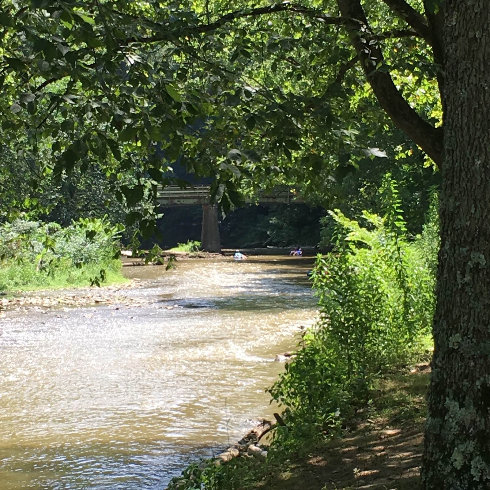
After about an hour or so, we reached a bridge which signalled the end of the ride, and after some mad paddling to the edge, we clambered out and made our way back up the road where a waiting mini bus very conveniently transported us and our tubes back to the Mill.


A lovely way to spend a couple of hours in high summer and well recommended as a way to beat the heat!


Thursday, May 12, 2016

The Susquehanna


The Susquehanna River is the longest running river on the east coast of the USA, starting in New York state and running through to the Chesapeake Bay in Maryland.  Close to us, it meanders roughly South East, through nearby Harrisburg and onwards, and effectively separates York from Lancaster.  (Hubby still can't used to the fact that York and Lancaster are "the wrong way round" here - Lancaster is East and York is West.)


As you'd probably guess, the origins of the River's name are American Indian, and "Susquehanna" reportedly comes from the Len'api term for "Oyster River".  It has played a key role throughout US history - most notably in 1863 during the Civil War Gettysburg Campaign.  The unionist forces determined that Robert E Lee's confederate army would not cross the Susquehanna on their rampage North, and positioned units to protect key bridges in Harrisburg and nearby (to us) Wrightsville.  They actually burned down the bridge between Wrightsville (to the west) and Columbia (to the east) in their efforts to stop the troops, and the confederate army had to form a bucket-brigade to prevent the rest of Wrightsville town from burning.


Prior to this, the Wrightsville bridge was once the world's longest covered bridge (a tad over 1800m).  It was destroyed once by high water and ice in 1832, and then again by the unionists in 1863, and then yet again by storms several years later.  You can still see the stone built pillars / piers from at least one of these iterations next to the current bridge.


The current bridge wasn't built until 1930, and was made of reinforced concrete.  Although still standing through the ravages of weather (parts of the Susquehanna do freeze over in the winter), it's still not immune to the challenges thrown at it by nature.  Last June, the bridge even made the BBC news website because of swarming mayflies which forced its temporary closure.  Apparently attracted to the new bridge lighting, the mayflies swarmed in such numbers that they caused poor visibility and subsequent car crashes.  Rumour has it that even cyclists struggled to pedal through the piles of dead bugs!

As another fun fact, the Susquehanna is also home to a second Statue of Liberty.  You can only see it when you're zipping along the motorway (which apparently caused more car crashes when it first appeared in the 80s).  It was originally built as a prank to honour the New York statue's 100 year anniversary, was built in a garage from plywood, and snuck out on canoes to be placed (highly illegally) on an old railway pier in the middle of the river. Sadly, it only lasted a few years before it perished in a storm and flood.  But locals missed their mini statue so much that they raised $25k to replace it.  The newer statue is still in place today, made from sturdier stuff (wood,metal and fibreglass), and stands much taller at 25 feet, even though she looks tiny when you whizz past in the car.


We're lucky to benefit from some local walking trails that follow parts of the Susquehanna River through Lancaster County, affording lovely views when the weather is good.  In particular, we've walked along part of Chickies Rock trail, when follows an old trolley line route and canal, and after a steep climb, ends on a huge outcrop 200 feet above the river. Near the trail there is also a protected Bald Eagle nest.  Chickies Rock is again based on an American Indian word for "place of the crayfish".  Very recently, they've opened up more of this trail, creating a 14 mile route along the River on the Columbia side, which we hope to walk (at least some of it) over the summer. 


We've also recently stumbled on a viewpoint just outside Wrightsville (called, unimaginatively, "Highpoint Scenic Vista"), which has a spiral track around the hill to the top for stunning views of the valley.  And also a nearby winery (aka vineyard), which is always welcome!


Friday, April 29, 2016

Penn's Cave


On a slightly blustery day back in March, we took a trip to "Historic Penn's Cave" in central Pennsylvania - about 2 1/2 hours drive from home.  Penn's Cave is a series of underground limestone caverns with beautiful stalagmite and stalactite formations, but with the unusual feature of only being navigable by boat.  Sounded like fun!


The caves were reportedly first discovered by the Seneca Indians, and there is an old Indian legend surrounding the caves and the ghost who may haunt them, as well as the origins of the Nittany Lion (now the Penn State Uni mascot).  They were first opened to the public in 1885, and an old Victorian hotel (now staff offices) sits close by, which used to host visitors to the cave.


The tour starts by descending a steep stone staircase into the mouth of the cave, where we met our tour guide and our "barge".  The relatively small area of daylit water is a temporary haunt of some large trout, who love to be fed by hand (they can only survive in the daylight waters, and presumably scoot back through the caverns to freshwater when they've eaten their fill!)  The caves are also home to the occasional owl (spot him?) and a large bat population (spot one?) during the winter months.  The caves stay a mild ~50 degrees throughout the year (50 degrees being the average temperature for the area).  


Spot the owl?
Spot the bat?
Once settled, the boat slowly made its way through the caves, mostly in darkness, with occasional modern lighting effects, or simply the tour guide's torch, to highlight some of the beautiful formations.  The caves are vast, and at times it was difficult to get a fix on the actual size of some of the areas we were shown.  And the tour only covers a very small percentage of the caverns which have been explored so far...  Lots of the shapes were named after everyday objects or famous sights, such as the Liberty Statue and Gibraltar Rock.  There was even a naturally formed heart shape.


The headroom got a little low at one point, too!


And then suddenly the air moved a little differently, a spot of daylight became visible, and we were back in the open, through the "back door" which links with the wildlife park also on site (sadly not yet open for the season when we visited).


After a little trip round the lake, and a long distance view of some of the residing animals, we headed back into the darkness again, through the caves for a last glimpse of the limestone forms, and then all too soon we were back at the stone staircase at the end of the tour.


We'll definitely be back - if only to get a proper glimpse of these bison!


Sunday, April 3, 2016

Toronto - Part 2


After all that walking, we decided a change of pace was needed, so the next day we took a trip or two on the "Hop On Hop Off" tour buses for a wider view of the area.  Have you ever noticed that these are always ex-London buses, which means you have to get in and out of the bus via the road in countries which drive on the right, which is always interesting...


The tour bus was by far the best way to see the sights, with added commentary, and we got great views from the top of the open top deck in the relatively mild weather.  (Just before we got on the bus, we did spot a random spiderman...)


We headed up Younge Street from it's originating point by the waterfront.  For a long time, this road was in the Guinness Book of Records for being the longest street in the world, but in 1999 they decided it was actually joined onto another, separate road (Ontario's Highway 11), and instead of the combined distance of 1178 miles, it actually measured only 53 miles...  Ooops.

We toured the Old Town district, past St Lawrence Market, the Distillery District and Toronto's first Post Office.  Then back into the midst of town where we stopped briefly for some shopping in one of the large malls.  


Then we hopped back on and headed up to Casa Lomo - allegedly North America's only full-sized "castle".  It's really a huge mansion house, which sits proudly on top of a hill overlooking Toronto, and was built in 1911 by Sir Henry Pellatt.  Spread across 5 acres, it was once the largest private residence in Canada, costing $3.5m.  Sadly it was only lived in for 10 years before Sir Henry was forced to abandon it due to financial misfortune.  There are lots of large stately rooms to explore, and some lovely gardens, although most of these were blocked off for a wedding later that day.  We also climbed through the extensive attic spaces to the top of one of the towers for more (breezy) views back across the city.


Our trip was coming to an end, but we couldn't leave without exploring the Waterfront area further, and decided to take a tour boat round the Toronto Islands.  These are situated just off-shore from the city centre, and are used mostly as recreational land, although there is also a small airport and a community of about 300 residents (considered the largest urban car-free community in North America).  I can imagine it would be very popular in the warmer summer months, with beaches, picnic areas, parkland, cycle hire, paddle boats and frisbee golf all available.  And as our boat headed back into harbour, we got some more great views of the city skyline, although the sky was a bit grey and threatening.


We explored a little further along the Waterfront itself, where there was a festival or two going on at the Harbourfront Center, as well as shops, bars and restaurants.  And then we finished the day with a spontaneous visit to a Comedy Club in town!


All too soon it was time to head home again, past the vineyards to the border, and then the long drive back to Lancaster...